Most people approach medieval villages in France as visual stops. They walk through a square, take a few photos, and move on. That approach misses the point of these places. These villages were built to organize people, control trade, and manage territory. Their layouts still reflect those decisions today.
Bastide towns across southwest France show this clearly. They were planned settlements built in the thirteenth and fourteenth centuries, designed around a central market square with a grid that made movement and taxation predictable.
Once you understand that structure, your experience changes. You stop moving randomly. You start reading the village through its layout, its constraints, and its logic.
This guide is built around that shift. Instead of listing places, it shows you how to interpret them, choose the right ones, and move through them without losing depth.
Why Bastide Towns Were Built: Power, Taxation, and Territorial Control
Most medieval villages in France did not emerge organically. Many bastide towns were deliberately founded in the thirteenth and fourteenth centuries as political and economic instruments. Rulers needed to secure contested regions, attract settlers, and generate predictable tax revenue. Planned settlements solved all three problems at once.
In southwest France, many bastides were established under figures like Alphonse of Poitiers through agreements known as paréage, where authority was shared between the crown and local lords. These agreements defined land division, governance, and taxation from the start.
This is why uniformity exists. Standardized plots ensured equal taxation. Grid layouts ensured visibility and control. Central squares concentrated trade where it could be monitored and taxed efficiently.
When you walk through these villages today, you are not seeing charm preserved by accident. You are seeing a system designed to stabilize power, extract revenue, and structure daily life with precision.
Best Way To Visit Medieval Villages In France Without Crowds And Rushed Itineraries
Most visits to medieval villages in France stay on the surface because movement follows tourist paths rather than the original structure. To understand these places, you need to align your movement with how the village was designed to function.
Visit Early Morning To Read The Village Layout
Arrive before commercial activity begins. Bastide towns were built around a central square that functioned as a market and control point. Roads were designed to feed into that square to facilitate trade.
When you enter early, you can see how streets connect without interruption. You can stand in the square and understand scale and alignment. Once crowds arrive, that structure becomes harder to read.
Walk The Grid Instead Of Following Tourist Paths
Many old French village layouts still follow the original grid planning from the thirteenth and fourteenth centuries. Streets intersect at controlled angles, and each block was designed for taxation and allocation.
Do not follow the main loop. Instead, move street by street. Track how each route leads back to the square. This reveals how the village managed flow and visibility.
Start From The Edge, Not The Center
Most visitors enter directly into the central square. That gives a distorted view of the village.
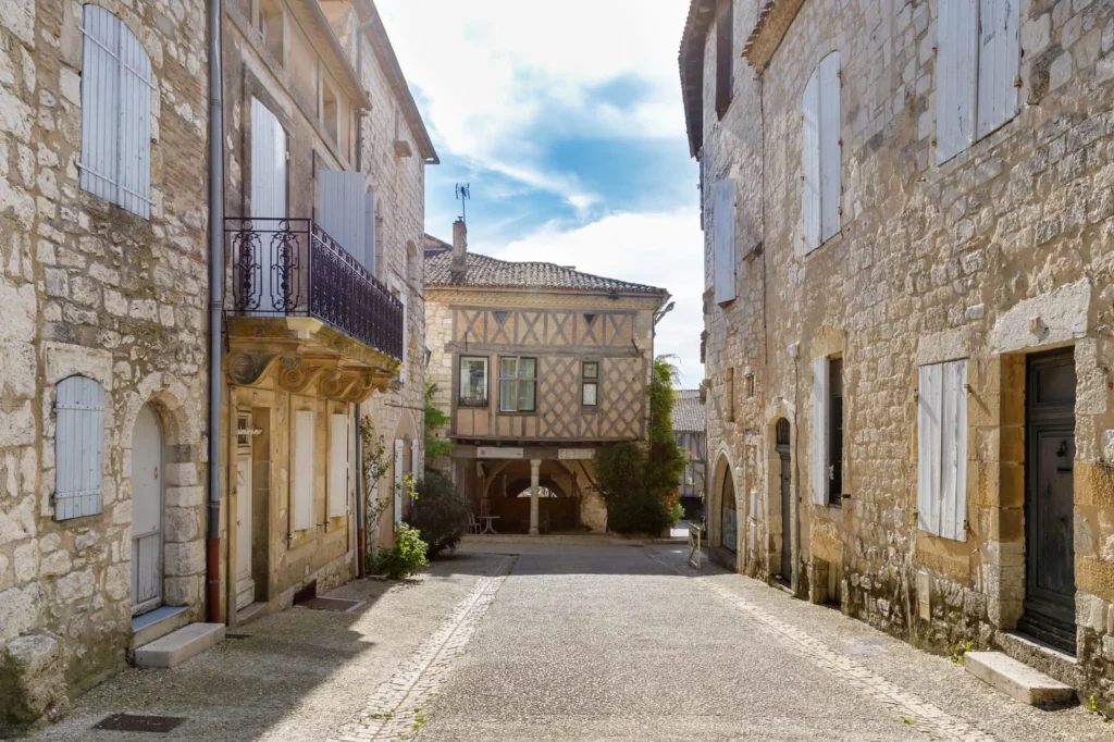
Start from the outer boundary. In many picturesque French villages, the edges preserve original building proportions and quieter circulation paths. These areas show how people actually lived, not how the village presents itself today.
Use Elevation Points To Understand Control
Many villages sit on ridges or controlled vantage points. This was deliberate. Height allowed surveillance and defense across the surrounding land.
Climb to the highest accessible point early in your visit. Look outward first, then back toward the village. This helps you understand why the settlement is located there.
Spend Time In One Zone Instead Of Covering Everything
A typical visit lasts one hour. That is not enough.
Stay in one area for an extended period. Watch how people move through the square. Notice how routes fill and empty. In bastide towns, movement patterns still follow the original commercial design.
That is where medieval villages in France become readable rather than decorative.
How To Analyze Layout, Stonework, And Planning Logic In Medieval Villages In France
Most guides tell you to “look at the architecture.” That advice is useless. In medieval villages in France, architecture only makes sense when you connect it to taxation, trade flow, and control systems. These villages were engineered environments. If you read them correctly, you can reconstruct how people lived, moved, and paid.
Read The Grid As A Taxation System, Not A Design Choice
Most people in medieval villages read the grid as a visual order. In reality, it functioned as financial infrastructure. Standardized plots made land measurable, enforceable, and taxable.
Across more than 300 bastide towns built in southwest France, this logic repeats. Streets run parallel to simplify division. Routes reconnect to the central square to funnel goods and transactions.
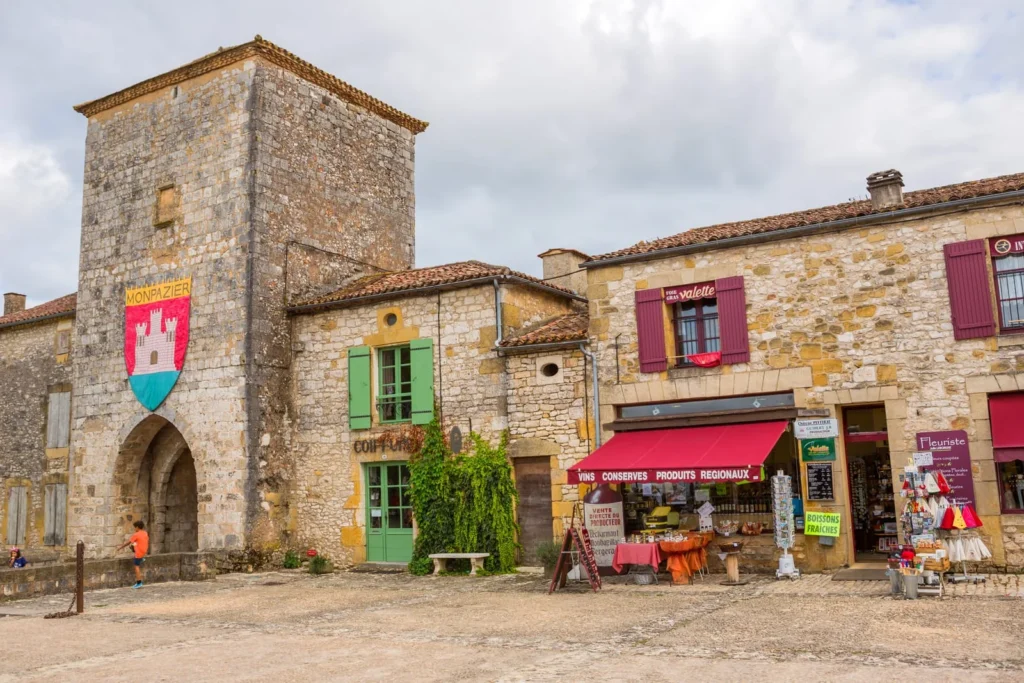
Take Monpazier as a clear example. Four primary streets run parallel and feed directly into the square. This is not symmetry. It is a system that organizes movement and revenue.
To read it on the ground, walk one street without turning and observe how straight it remains. Then track how often routes reconnect to the square. That loop shows how goods and taxation were controlled.
Understand The Central Square As A Control Mechanism
The square was not placed randomly. In many bastides, it does not sit at the exact intersection of main roads. Instead, access happens from the edges or corners.
That design forces movement to bend and slow before entering the market space. It provides visibility to authorities responsible for trade and taxation.
Also, notice what is missing. The church often sits off-axis. That placement reflects priority. Trade-generated revenue. Religion did not. If you stand in the square and track how streets feed into it, you can see how commerce was controlled.
What Was Actually Traded Here: The Economic Layer Most Guides Ignore
Understanding structure without understanding trade leaves the system incomplete. Medieval villages in France were not just organized spaces. They were economic engines tied to regional supply chains.
In bastide towns across Dordogne and Gascony, markets typically revolved around grain, wine, salt, and livestock. Weekly markets served as local exchanges, while seasonal fairs drew merchants from broader regions.
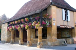
The central square functioned as a regulated marketplace. Arcades provided covered areas where merchants could operate regardless of the weather. This ensured continuity of trade and consistent tax collection.
Location mattered. Villages near rivers or trade routes show more refined stonework and better infrastructure because goods moved through them more efficiently. More trade meant more revenue, which justified investment in construction quality.
When you stand in the square, you are not just looking at space. You are standing inside a controlled economic system that links rural production to regional distribution.
Decode Stonework By Supply Chains, Not Style
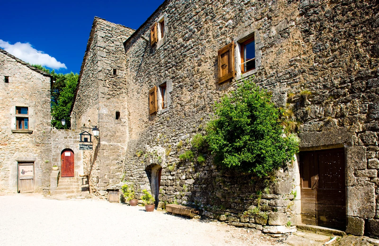
Stone variation across a village is not random aging. It reflects access to materials and transport routes.
Villages closer to the river or along major routes show more uniform cut stone. Remote areas rely on irregular local stone with inconsistent sizing. This difference maps directly to economic connectivity.
Also, look at the arcades around the square. These covered walkways protected merchants and goods. They also created a controlled commercial perimeter in which transactions were conducted under supervision.
Stone here tends to be more refined because this was the economic core.
Use Street Width And Compression To Identify Power Zones
Street hierarchy is one of the clearest signals most people miss.
Main carriage routes remain wide because they were designed for goods transport. Secondary lanes narrow sharply. This was intentional. Narrow streets reduce speed and increase control near entry points.
In fortified villages, this compression often happens just before gates or transitions. It creates a physical bottleneck that regulates entry.
Walk from the outer edge toward the square and track where the width changes. That shift marks the transition from defense to commerce.
Identify Construction Phases Through Inconsistency
Even in highly planned villages, you will see breaks in uniformity. These are not flaws. They mark later adaptations.
Look for:
- Changes in stone size within the same wall
- Windows that break alignment with neighboring facades
- Rooflines that interrupt a consistent slope
These signals often indicate expansion, rebuilding after conflict, or economic shifts. Many bastides were modified during the Hundred Years’ War, with fortifications added after initial construction.
You are not looking at a frozen moment in time. You are looking at layers of decisions.
How To Pick The Right Medieval Villages In France Without Repeating The Same Experience
Different medieval villages in France preserve different systems. Some maintain planned uniformity, while others reflect terrain, defense, or long-term adaptation. If you do not distinguish between these, your itinerary becomes repetitive.
Start by identifying what still works on the ground. In Monpazier, repetition is intact. Street alignment, plot width, and arcade spacing still follow a consistent pattern. This reflects a fiscal system where land division and taxation required uniformity.
In contrast, Les Baux-de-Provence reveals control through restriction. Entry routes bend and narrow before opening into the settlement. This creates friction and slows movement, which reflects defensive planning rather than economic organization.
Then you have villages like Saint-Cirq-Lapopie, where terrain overrides planning. Streets shift direction, and houses follow the slope rather than a grid. This shows how geography reshaped structure.
Finally, Eguisheim shows long-term growth without strict control. Its circular form looks organized, yet internal inconsistencies in spacing and alignment reveal expansion over time.
Choosing one village from each of these types gives you contrast. Choosing five from the same type gives you repetition.
How To Plan A Route Across Medieval Villages In France That Builds Understanding
Most routes are built around distance. That approach keeps you inside one structural pattern. A better route spans multiple systems, so each stop adds a new layer of understanding.
- Start in Dordogne with Monpazier. This gives you a clear reference point for controlled planning. You see how repetition organizes movement and how the square acts as the economic center.
- Then move to Provence and visit Les Baux-de-Provence. The experience shifts immediately. Movement slows, access becomes restricted, and the layout feels defensive rather than open.
- Next, go to the Lot region and visit Saint-Cirq-Lapopie. Structure begins to bend. Streets follow terrain instead of logic imposed from above.
- After that, move to Alsace and explore Eguisheim. Patterns become less predictable. You begin to see how villages evolve when central control weakens.
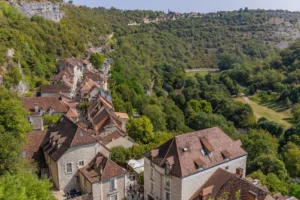
- If you include Rocamadour, you introduce an entirely different dimension. The village organizes itself vertically, with movement forced upward and functions stacked along the cliff.
This sequence matters. Moving from structured to adaptive environments allows you to recognize differences clearly. If you reverse it, everything starts to blur.
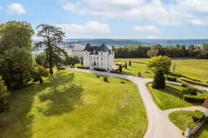
Experience Structure, Not Just Scenery: Stay at Château de Lasfonds
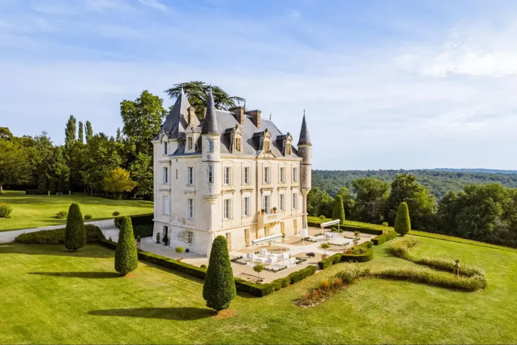
If you want to move beyond observation and actually experience how rural France operates at a slower, more structured rhythm, staying at Château de Lasfonds offers a different level of immersion. Instead of passing through villages, you stay within the same landscape system that shaped them.
This nineteenth-century château sits on a hill between Charente and Dordogne, positioned within the same network of villages, trade routes, and agricultural land you’ve been reading about. Built between 1849 and 1893 and later restored, it reflects a later phase of rural organization, where estates shifted from defensive or fiscal systems toward private ownership and managed landscapes.
The setting matters. The estate spans over six hectares of countryside, surrounded by forests, farmland, and low-density settlement patterns that still follow historical land division. From here, nearby medieval villages are not isolated destinations—they become part of a continuous system you can move through and interpret.
Unlike hotels in dense tourist zones, Lasfonds operates as a contained environment. You control your time, your movement, and your pace. The château accommodates small groups, typically up to 18–20 guests, with a main residence and additional guest houses spread across the estate. This structure mirrors how land and living space were historically distributed—central authority with surrounding extensions.
What makes it relevant to your journey is not luxury alone. It is perspective. From here, you can:
- Visit bastide towns like Monpazier early, before movement patterns shift
- Compare structured villages with terrain-driven ones like Saint-Cirq-Lapopie
- Return to a quiet base that reflects how rural systems actually function
You are no longer just reading villages. You are moving through the same geographic logic that shaped them.
If you want to experience medieval villages in France as lived geography rather than visual stops, this is where that shift becomes real. Book your stay at Château de Lasfonds and anchor your journey in the landscape itself.
FAQs about Medieval Villages in France
1. What are the best medieval villages in France for understanding historical layout and planning?
The best medieval villages in France for layout and planning include Monpazier, Domme, and Eguisheim. Each preserves a different structural system. Monpazier shows grid precision, while others reveal adaptation, helping you compare how design shaped daily life.
2. Why were bastide towns built in medieval France instead of growing naturally?
Bastide towns in medieval France were intentionally built to control land, attract settlers, and generate tax revenue. Rulers used structured layouts and shared governance agreements to manage growth and stabilize contested regions.
3. How can you visit medieval villages in France without crowds and tourist congestion?
To visit medieval villages in France without crowds, arrive early and begin from the outer edges. Move slowly through side streets instead of central routes. This helps you experience the original layout before modern tourist flow disrupts it.
4. What makes a medieval village in France different from other European villages?
A medieval village in France, especially a bastide, often follows a planned grid with a central square. Unlike organic Italian or defensive Spanish towns, these settlements prioritize structure, trade, and taxation, resulting in a more readable, consistent layout.
5. How do you identify a bastide town when visiting medieval villages in France?
You can identify a bastide town in France by its grid streets, central market square, and evenly sized plots. These features reflect deliberate planning for taxation and trade, rather than gradual, organic growth over time.
6. What was the purpose of the central square in medieval French villages?
The central square in medieval French villages served as a controlled marketplace. It concentrated trade, enabled taxation, and allowed authorities to monitor activity. Arcades and structured access points helped regulate the flow of goods and people through the space.
7. Are all medieval villages in France built on a grid system?
Not all medieval villages in France are laid out in a grid. While bastides are planned, many villages adapt to terrain or evolve over time. This variation reflects geography, local needs, and historical changes rather than a single planning approach.
8. What role did trade routes play in shaping medieval villages in France?
Trade routes in medieval France determined where villages developed and how they grew. Settlements near rivers or key routes attracted merchants, leading to better infrastructure, more consistent layouts, and stronger economic activity over time.
9. How many bastide towns exist in France, and are they still preserved today?
There are hundreds of bastide towns in France, many of which still preserve their original layouts after centuries. Some remain highly intact, like Monpazier, offering rare insight into medieval planning and economic organization.
10. Where should you stay to explore medieval villages in France more effectively?
To explore medieval villages in France more effectively, stay in a rural base near bastide regions like the Dordogne. This allows you to visit multiple village types within one system and understand how geography, trade, and planning connect across locations.